

In Nottingham, we see streets as PLACES, ecologies we share with other species. Vehicles happen to be able to circulate through these ecologies.
We support a people-first design ethos and therefore, streets should not be designed primarily with vehicles in mind.
Nottingham City strongly advocates the inclusion of cycling lanes and sustainable drainage measures (see the Drainage page) from early stages in the design concept. How to integrate these into the street design, and how these would be adopted, has to be discussed with the relevant specialist officers. Please get in touch with your case officer to discuss this, not considering cycling and/or water management from the outset through design could lead to planning delays and potential refusal.
street Classification - Overall Dimensions

Street Hubs
These are main connectors, streets where one expects to see buses, cyclists and heavier traffic. Example: Mansfield Road, Carrington.

Street Kits
These are the type of streets one would see as distributors within neighbourhoods. Example: Robin Hood Way, The Meadows.

Co-Streets
These are quiet, neighbourhood streets that bring people together. Example: Woodville Road, Sherwood.
Download
To download this page in PDF format, open the print menu by pressing Ctrl+P. Under the “Printer” drop-down menu, select “…Print to PDF” or “Save as PDF” (the exact wording may vary by browser). Click “Print”.
Street Ecology Ethos

Streets should serve the built form, humans and nature; not just vehicles.

The social function of streets varies across the different hierarchies, as people look for a built environment that suits their lifestyles and needs.

Street hierarchy according to the street function and the built form they serve.

Nature should be integral to the design of streets from the outset. Each street hierarchy can accommodate nature in different ways.
Street Classification - Technical illustrations
SH1.1 Avenue
Definition: a broad road in a town or city, typically having trees at regular intervals along its sides.


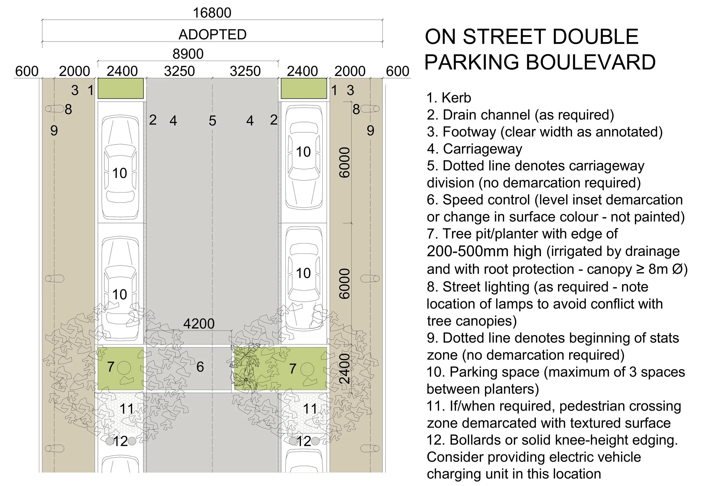
SH1.2 Boulevard
Definition: a wide street in a town or city, typically one lined with trees.


SH2. Main Street
Definition: the principal street of a town, traditionally the site of shops, banks, and other businesses; streets that might require a bus route in the future.


SK3. residential Street
Definition: streets in residential areas that will never have bus services through, but that serve up to 50 dwellings.


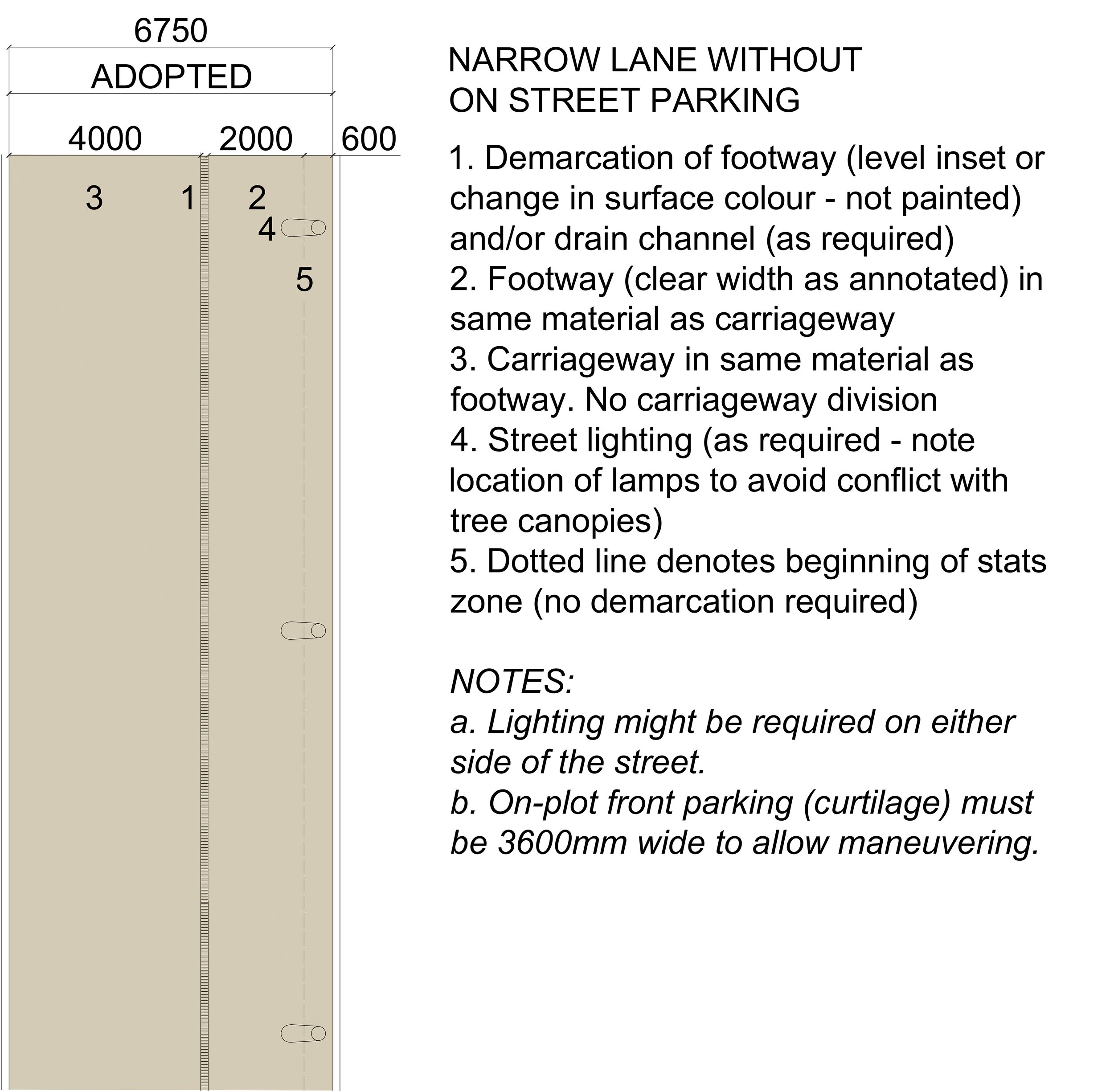
SK4. Lane
Definition: a narrow road, especially in a quiet area.


CS5. Mews
Definition: a row or street of houses or flats that have been converted from stables or built to look like former stables; a group of stables, typically with rooms above, built round a yard or along an alley. Mews must not be dead ends; fully connected Mews are preferable but pedestrian/cycling connection only would be acceptable.


CS6. Private Street
Definition: Private Streets are those that are not adopted by Nottingham City Council’s Highways Authority. Despite not adopting the streets at present, the city must be future-proof, and therefore, the design criteria below apply to all private streets.
CS6. Design Criteria
CS6.1 Be built to adoptable standards (material specifications and dimensions)
CS6.2 Adopt the Co-Streets typologies (Lane or Mews - see above)
CS6.3 Serve a maximum of 6 homes
CS6.4 Waste collection for the homes served must be provided within the adopted highway network
CS6.5 Avoid huge turning heads
CS6.6 Provide pedestrian-cycling permeability by being linked to the highways network
