
ABOUT THE BGR DESIGN GUIDE

This guide is for anyone planning, designing and/or delivering blue, green and red infrastructure in the city. This guide shows minimum expectations for public realm, private spaces open to the public and adopted highways involving GBR infrastructure.
BEST PRACTICE BGR DESIGN GUIDE
OVERARCHING DESIGN PRINCIPLES
1 People first design: Accessible & inclusive; healthy; feels safe; caters for moving and dwelling; legible; navigable
2 Climate resilient: Climate-responsive design; planned for future retrofit of unaffordable technologies
3 Space for nature: Designed for the whole urban ecosystem, including other species
4 Connected networks: Helps connect people; connect green, blue and red networks and use urban greening mechanisms (tree canopy, street greening, green walls, etc.); secure legible links to transport and services
5 Slow the water flow: Permeable; natural water management; multi-function
6 Celebrate and respect heritage: Design to enhance the sense of place identity and local culture; protect and highlight historic assets
7 Favour local economy: Include infrastructure and plan for services that enable social and economic activity like commerce and festivals
8 Collaborate and maximise co-benefits: Identify local partners and stakeholders and work with them from day one; capitalise on common goals and aspirations; seek opportunities for co-funding and co-delivery
9 Secure long-term maintenance systems: Ensure long-term stewardship mechanisms are in place; design to minimise potential conflict
10 Monitor social value (SV) delivery: Engage with experts to capitalise on the design process to deliver SV; use the DQF template to monitor SV delivery
BLUE INFRASTRUCTURE
Design
B1. Align proposals with the National Standards for Sustainable Drainage Systems and design SuDS and public realm to work with flow routes and move water around in line with natural topography
B2.Use SuDS or green spaces to remove connections to drainage networks
B3. Intercept rainfall with features to slow the flow. Public realm to be designed to intercept the first 5mm of rainfall (daily rainfall)
B4. Design SuDS and green spaces to improve quality of runoff before it enters a piped network or watercourse
B5. In large public realm schemes/developments, store water in SuDS and green spaces up to the 1 in 100 year event plus climate change
B6. Ensure features act as corridors to connect wildlife, green space and people, as well as connectivity to existing blue networks (e.g. rivers, canals and open spaces)
B7. Design for climate change resilience and adaptation – introducing features for cooling e.g. tree pits, canopies and choose climate adaptive species
B8. Use SuDS to improve safety in highway settings, whilst also designing in safety measures, particularly for blind and visually impaired communities
Placemaking
B9. Maximise multiple uses of water to increase wider public wellbeing, biodiversity and the local economy, designing water to be an asset – e.g. water features, and assess site requirements for water use - e.g. water supply provision for events; drinking water supply in areas identified as high heat locations
B10. Provide and maintain up to date education, interaction & interpretation boards
B11. Embed work of local artists and interactive cultural references to enhance the sense of place
Maintenance
B12. All proposals must require low or minimal maintenance. A water management and maintenance plan must be submitted as part of the planning application

As cities face heavier rain and rising heat, water is becoming essential infrastructure. But it also supports health, wellbeing, and everyday enjoyment. Reconnecting people with water is critical.
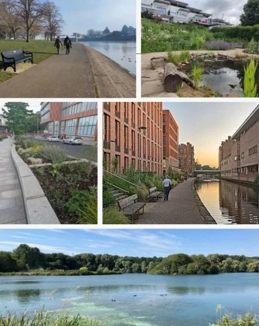
What blue looks like
Working with natural flow routes and topography
Intercepting rainfall and slows the flow
Improving runoff quality before it enters pipes or watercourses
Reducing the Flood/Drought extremes by storing water in extreme wet weather and slowly releases it afterwards.
Supporting green infrastructure
GREEN INFRASTRUCTURE
Design
G1. Design generous size green infrastructure that is above the minimum requirements for the scheme
G2. Link the design to the broader infrastructure to build networks across the city
G3. Select climate conscious species. “Native” is not always the right choice for a city context, consider climate change/ heat island/ pollution effects.
G4. Plant following a biodiversity-focused strategy
G5. Including large and long-lived tree species wherever feasible, demonstrating canopy cover contribution to the area
G6. Integrate SuDS and water management features with the green infrastructure (see B8)
G7. Demonstrate appropriate consideration to soil specification to keep weed and irrigation pressures down.
G8. Specify and procure materials of high quality, obtained from reputable sources to ensure long term performance
Placemaking
G9. Provide integrated active travel to encourage connections with nature and to help minimise air pollution
G10. Design to encourage everyday connection with nature - e.g. active travel, natural play, etc.
G11. Design to instil a sense of community pride, considering shared ownership, stewardship and volunteering schemes
Maintenance
G12. All proposals must require low or minimal maintenance. A maintenance plan that demonstrates long term biodiversity enhancement and alignment with Nature Friendly Design must be submitted as part of the planning application

All new green infrastructure must form an integral part of the wider network, delivering joined-up ecological and social value by supporting both community needs and the conditions for wildlife to thrive.
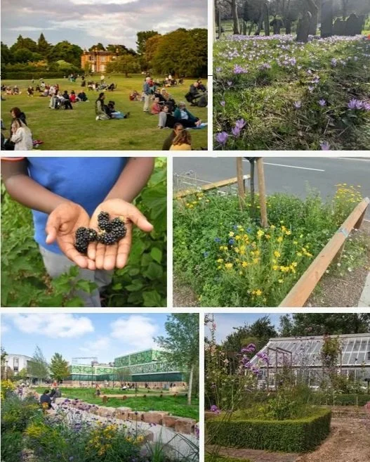
What green looks like
Building connected networks and wildlife habitats across the city
Providing spaces to stay active, healthy and relaxed
Using climate-conscious species
Supporting biodiversity by adding habitat value as well as beauty
Designing around soils, longevity and canopy cover
RED INFRASTRUCTURE
Design
R1. Provide clear, uncluttered, inclusive movement zones catering for every need (pushchairs, mobility aids, etc.), ensuring sit and rest provision in a shaded area that feels safe, therefore contributing to the increase in footfall
R2. Provide spaces for people to meet, socialise and spend time together and in direct contact with nature - e.g. pic-nic tables and bins, group sitting, etc.
R3. Provide spaces that can host spontaneous and planned activities and events, and which have all the key services catered for - waste, power, water, drainage, etc.
R4. Ensure the space is easy to navigate from a pedestrian perspective so that people can find their way round intuitively - e.g. use Kevin Lynch’s mental mapping strategies
R5. Future-proof the design for climate adaptation, with alternative zones for shade and sun, and provision for public water taps to be retrofitted when the need arises (see B7)
R6. All public realm must be considered as part of a larger network, this means understanding the hierarchy in terms of function, significance and impact on the economy in the context of existing public realm activity. The role of the new space as a contributor to the local economy must be clear by design, especially in relation to independent businesses, start ups and cultural offer
R7. Demonstrate how cultural and sports networks will benefit and could contribute to the new public realm, including creating opportunities for events and festivals to extend onto the new public realm.
B8. Specify materials that can be easily replaced at affordable prices, and design details appropriately to keep any loose material (pebbles, bark, etc.) away from footpaths.
Placemaking
R9. Ensure the design denotes seasonal changes that help create a sense of passing of time - e.g. colour changes, de-leafing, foraging opportunities, etc.
R10. Demonstrate how local social and businesses networks will benefit and could contribute to the new public realm, including creating opportunities for sponsorship, volunteering, co-ownership and other forms of stewardship
R11. Follow the Age-friendly principles of the Design Quality Framework: www.dqfnottingham.org.uk/agefriendly-design
Maintenance
B12. Provide a maintenance plan that includes access road specifications, whether they are adopted or not. Highlight stopping up requirements for maintenance access, vehicular tracking for cherry pickers, emergency and service/maintenance vehicles

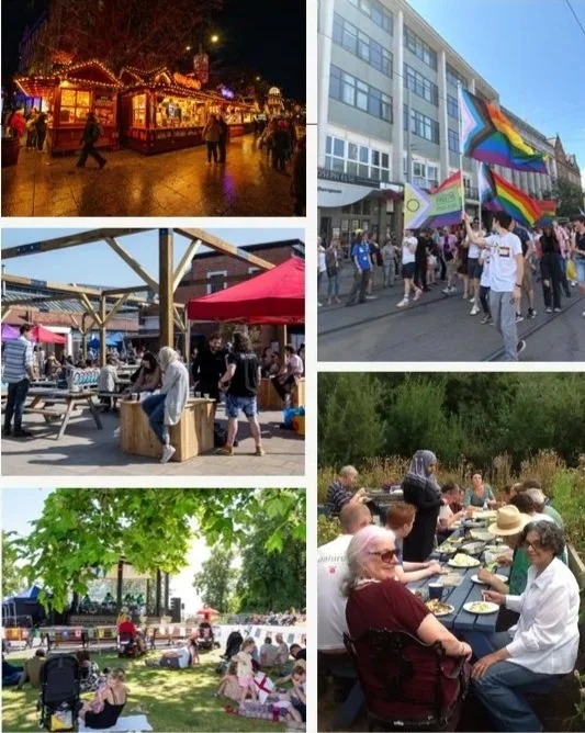
What red looks like
Creating clear, inclusive movement zones and shaded rest points
Providing places to meet, socialise and dwell
Enabling spontaneous and planned activities
Activating the economy, culture and sports
Rebalancing inequalities by prioritising the areas where provision is lowest